INTRODUCTION
 On January 2, 2002 (UTC -3 January,
local date), a powerful earthquake struck Vanuatu, a group of
about 80 islands in the Southwest Pacific with a population of
about 190,000 people (previosuly known as New Hebrides). The earthquake caused extensive damage
in the capital, Port-Vila, (a town of about 19,400) and surrounding
areas on the island of Efate. A small tsunami was generated.
This was the most destructive event in the Vanuatu Archipelago
since the 26 November 1999 earthquake and tsunami struck the
northern island of Pentecost, a town of about 12,000 people.
The 1999 tsunami left thousands of people homeless.
On January 2, 2002 (UTC -3 January,
local date), a powerful earthquake struck Vanuatu, a group of
about 80 islands in the Southwest Pacific with a population of
about 190,000 people (previosuly known as New Hebrides). The earthquake caused extensive damage
in the capital, Port-Vila, (a town of about 19,400) and surrounding
areas on the island of Efate. A small tsunami was generated.
This was the most destructive event in the Vanuatu Archipelago
since the 26 November 1999 earthquake and tsunami struck the
northern island of Pentecost, a town of about 12,000 people.
The 1999 tsunami left thousands of people homeless.

 THE EARTHQUAKE
The earthquake occurred
at 17:22:49 on 2 January 2002 (UTC)(or 04.22 hrs on 3 January,
local time and date). Its magnitude was 6.3mb (7.5MS) and its
focal depth about 21 km. The epicenter was at at 17.78S, 167.88E
(USGS), approximately 45 km West of of Port Vila. A
number of aftershocks were recorded.
Vanuatu Seismicity and Epicenter of 2 January 2002 Earthquake (USGS)
 |
TECTONIC SETTING OF THE REGION
 The
entire region where Vanuatu island group is located is characterized
by high volcanic and seismic activity and is part of what is
often referred to as the " Pacific Rim of Fire" - an
area notorious for frequent earthquakes and volcanic eruptions.
This region of the Southwest Pacific Ocean is presently responsible
for about ten per cent of the total energy released by earthquakes
in the world.
The
entire region where Vanuatu island group is located is characterized
by high volcanic and seismic activity and is part of what is
often referred to as the " Pacific Rim of Fire" - an
area notorious for frequent earthquakes and volcanic eruptions.
This region of the Southwest Pacific Ocean is presently responsible
for about ten per cent of the total energy released by earthquakes
in the world.
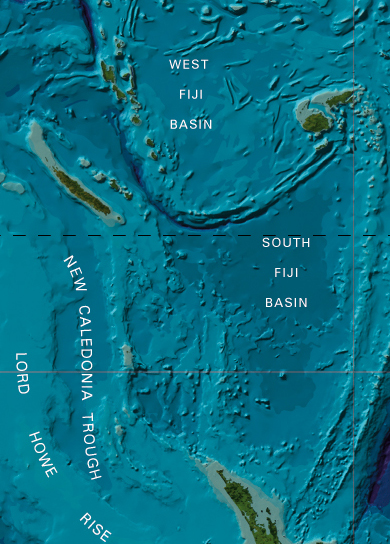
Bathymetry of a segment of the SW Pacific Ocean showing the New Hebrides Trench, the North and South Fiji Basins, the New Caledonia Trough and the Lord Howe Rise.
 |
The 2 January 2002 earthquake
occurred along a zone where tectonic plate convergence and subduction
take place, as the Pacific tectonic plate submerges beneath the
Australian plate. In the Vanuatu area this process of subduction
has formed the New Hebrides Trench and is the cause of major
earthquakes and locally destructive tsunamis. The tectonic plates
move at speeds averaging between 1 cm and 10 cm per year. As shown the adjacent map, the Australian plate also shares boundaries with the Philippine Plate,
the Indian Plate, the Somali Plate, the Eurasian plate and the
Antarctic plate.
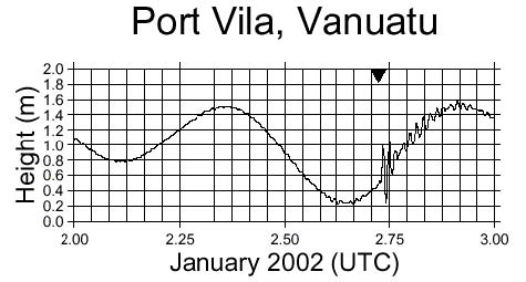
 THE TSUNAMI
Historically, only
local tsunamis are generated by earthquakes in the region. The January 2, 2002
quake generated a local tsunami. It took 14 minutes after the
quake for the first wave to reach the Port Vila tide gauge station,
the closest to the earthquake's origin. The maximum recorded
tsunami wave was 0.8 m (trough to crest). The average period
was about 11 minutes (see tide gauge record below).
Map showing the New Hebrides Trench and the epicenter of the November 26, 1999 shallow earthquake (33km) at 16.452 South, 168.183 East, approximately 90 miles north of Port Vila - which was felt throughout the islands of Vanuatu. Numerous aftershocks of decreasing intensity continued in the days following the main event.
However, as with the
November 1999 event, the Port Vila gauge tsunami recorded height
does not represent the maximum runup observed elsewhere in the
harbor or along the open coasts. According to eyewitness reports the maximum tsunami runup
at different parts of PortVila , was about 3.0 meters - large
enough to cause damage. However, most of the local damage was caused
mainly by the earthquake.
A large aftershock
on the following day generated another small local tsunami, which
was recorded by the Port Vila tide gauge to be less than 10 cm. Its height on the open coast is not known.
Port Vila - Tide Record of the Tsunami
of 2 January 2002 as recorded in Port Vila
|
Port Vila Tide Gauge Record of the Tsunami
 |
DEATH TOLL AND
DAMAGES
Several people were injured but
there were no reported deaths. Fearing a tsunami, hundreds of
residents had fled to higher ground. Damage at Port Vila and
other areas on Efate Island was widespread but was caused primarily
by the earthquake and resulting landslides. Access to the wharf was blocked by rockslides. Buildings in the business
district of the town were damaged and shops had broken windows.
Ground liquefaction was responsible for most of the damage to
homes, buildings, structures and embankments. Three bridges were
reported damaged or destroyed.
MAJOR EARTHQUAKES IN THE VANUATU REGION FROM 1976 TO 2011
(Based on Search of the USGS-NEIC File for Magnitude Range: 7.0 - 10.0 and from Latitude: 17.000S - 22.000S Longitude: 171.000E - 165.000E included is the 1999 event further south)
| |
Year Month Day |
Origin Time |
Latitude (South) Longitude (East) |
Depth |
Magnitude |
| |
1976 08 02 |
10:55:25.70 |
-20.61 169.27 |
52 |
7.0 |
| |
1979 05 01 |
13:03:37.10 |
-21.24 169.80 |
79 |
7.2 |
| |
1980 10 25 |
11:00:05.10 |
-21.89 169.85 |
33 |
7.2 |
| |
1981 07 15 |
07:59:08.47 |
-17.26 167.60 |
30 |
7.1 |
| |
1990 03 05 |
16:38:12.57 |
-18.32 168.06 |
20 |
7.1 Mw |
| |
1990 08 12 |
21:25:21.95 |
-19.43 169.13 |
140 |
7.1 Mw |
| |
1992 10 11 |
19:24:26.29 |
-19.25 168.95 |
129 |
7.4 Mw |
| |
1993 12 29 |
07:48:14.20 |
-20.23 169.79 |
33 |
7.0 Mw |
| |
1994 02 12 |
17:58:23.99 |
-20.55 169.36 |
27 |
7.0 Mw |
| |
1999 11 26 |
|
|
|
|
| |
2002 01 02 |
17:22:48.76 |
-17.60 167.86 |
21 |
7.2 Mw |
| |
2007 03 25 |
00:40:01.61 |
-20.62 169.36 |
34 |
7.1 Mw |
| |
2008 04 09 |
12:46:12.72 |
-20.07 168.89 |
33 |
7.3 Mw |
| |
2010 08 10
2010 12 25 |
05:23:44.98
13:16:36.90 |
-17.54 168.07
-19.73 167.90 |
25
12 |
7.3 Mw
7.3Mw |
The Big One - The Next Great California Earthquake