|
MAJOR
EARTHQUAKES IN JAPAN AND THE SOUTHERN KURIL ISLANDS IN THE 20TH
CENTURY
George
Pararas-Carayannis

Tectonic
Setting of the Northern Japan/Kuril Island Region
The overall tectonics
of northeast Asia are very complicated. Whether the Sea of Okhotsk
and the northern Japanese islands are part of the North American
plate or of a separate Okhotsk plate has not been determined.
On the Pacific Ocean side, earthquake slip vectors along the
Kuril and Japan trenches are consistent with either a Pacific-North
America or a Pacific-Okhotsk plate motion. We will assume that
the Pacific-North America plate motion is better supported.
 The Kuril island arc is located
between the Kamchatka Peninsula and the Japanese island of Hokkaido.
The Kuril Trench has been formed by the subduction of the Pacific
plate under the North American plate. It extends from the offshore
central area of Kamchatka to Hokkaido. The Kuril island arc is located
between the Kamchatka Peninsula and the Japanese island of Hokkaido.
The Kuril Trench has been formed by the subduction of the Pacific
plate under the North American plate. It extends from the offshore
central area of Kamchatka to Hokkaido.
The plate tectonics of the Southern Kuril islands-Northern Hokkaido
region are very different than those along the southern portion
of the Japanese Trench. The South Kuril Islands are part of the
Kuril arc in the Okhotsk plate which has been colliding westward
against the Northeast Japan arc, along the Hidaka Collision Zone
(HCZ), where new continental crust is created by active arc-arc
collision.
Deep seismic reflection studies (Ito, Kazuka @Abe, 2001) show
the lower crust of the Kuril arc to be delaminated at a depth
of about 23 km. These studies indicate that the upper half (above
23 km) - consisting of the earth's upper crust and the upper
portion of lower crust of the Kuril arc - is thrusting over the
Northeast Japan arc along the Hidaka Main Thrust (HMT). However,
the lower half (below 23 km) - consisting of the lower portion
of lower crust and upper mantle material - is descending downward.
As a result of such
kinematic processes, the wedge of the Northeast Japan arc is
intruded into the delaminated Kuril arc, as the Pacific plate
is subducting northward beneath both of the above mentioned structures,
thus continuing the arc-arc collision (and continental crust
production). The complex, seismo- tectonic kinematic process
of this region has been named "Delamination-wedge-subduction
system" - which may apply also to other areas where active
arc-arc collision and concurrent subduction take place.
Accordingly, Hokkaido - Japan's northernmost island - extends
northeast into Kuril Islands and is composed of multiple compressed
island arcs. The northern half of Honshu (north of Tokyo), which
is Japan's main island, represents a typical mature island arc,
while the southern half of the island represents also a typical
mature island arc, as the Philippine Sea plate subducts below
the Eurasian plate.
On the western side, the Sea of Japan is a complex basin between
Japan and the Korea/Okhotsk Sea Basin. It represents another
subplate with apparent rotational movement as it interacts against
the Okhotsk plate, along the inland sea boundary of the Hidaka
Collision Zone (HCZ).
Sakhalin island, north of Hokkaido, which separates the Sea of
Japan from the Sea of Okhotsk, is probably the result of transpressional
tectonics along the North America-Eurasia boundary.

Subduction
and Arc-Arc Collision
Subduction and volcanic
arc-arc collision along the Japan and Kuril Trenches have been
primarily responsible for many large historical earthquakes,
on the Pacific side of Northern Japan and the South and Central
Kuril island region
The Pacific plate converges into northeastern Asia (the Okhotsk
subplate which is part of the North American plate, separated
from the Eurasian plate by the Hidaka Collision Zone (HCZ)).
The rate of tectonic convergence along the Kamchatka, Kuril and
Japan trenches is estimated at about 8-9 m per century - which
is a very high. Hokkaido, which extends northeast into Kuril
Islands is composed of multiple compressed island arcs.
In the past two centuries this fast rate of subduction has triggered
several large earthquakes with magnitudes of up to 8 or more
along the southern Kuril trench, near the island of Hokkaido.
However, these historical earthquakes have ruptured segments
of the trench and of the forearc region that have been only in
the range of 100-200 km long. Thus, these must be considered
as characteristic of most plate-boundary earthquakes for this
volcanic arc region.
The recent earthquake of November 15, 2006 - like those of 1994
and of 1963 - occurred on the Pacific side boundary of the smaller
tectonic subplate which includes the Sea of Okhotsk and possibly
a portion of the northern part of the Sea of Japan (Pararas-Carayannis,
1995).
Apparently, the grinding motion of the North Pacific Plate against
this subplate, results in larger earthquakes - such as those
of 1963 and 1994 - but apparently with less vertical subduction
and more rotational movement. For example, the 1994 quake resulted
in only about 50 cm of land subsidence but in extensive lateral
movement at Shikotan Island. A greater amount of subsidence would
have been expected, given the earthquake's large magnitude.
Seismicity
of the Northern Japan/Kuril island Region
The Southern Kuril
islands and Japan is one of the world's most earthquake-prone
regions in the world. Around 20 per cent of the world's earthquakes
take place in this region. The seismicity of Northern Japan is
the result of a double seismic zone (DSZ), and compressional
deep trench and outer rise events and is caused by the magmatic
effects of plumes or superplumes which, originally, may have
hydrated the subducting oceanic lithosphere. Usually, shallow
normal faulting occurs in the trench-outer rise region.

MAJOR
EARTHQUAKES IN JAPAN AND THE SOUTHERN KURIL ISLANDS IN THE 20TH
CENTURY
* 1923 - SEPTEMBER
1, : Tokyo, Magnitude
8.3, 140,000 dead.
* 1933 - MARCH 2
: Tsunami caused
by quake off northeastern coast, Magnitude 8.9, 2,990 dead.
* 1946 - DECEMBER
21: Shikoku, Western
Japan, Magnitude 8.0, 2,000 dead.
* 1948 - JUNE 28
: Fukui, Western
Japan, Magnitude 7.1, 3,769 dead.
* 1952 - MARCH 4
: Hokkaido, Magnitude
8.2, 8,233 dead.
* 1963 - OCTOBER 13 - Southern Kuril Islands (MS=8.1, I=2.5) - Urup
tsunami.
* 1964 - JUNE 16:
Sea of Japan - (MS=7.5)
- Niigata tsunami (26 dead).
* 1968 - MAY 16 : Tokachi, Eastern Hokkaido, Magnitude
7.9, 52 dead.
* 1969 - AUGUST 11
- Kuril Islands (MS=7.8,
I=2.0) - Shikotan tsunamis.
* 1983 - MAY 25 : Northern part of Sea of Japan,
Magnitude MS= 7.7 (104 dead).
* 1993 - JANUARY
15 : Kushiro, Hokkaido,
Magnitude (MS=7.8), Kushiro tsunami, one dead.
* 1993 - JULY 12
: Japan Sea - Okushiri,
Hokkaido, Magnitude (MS=7.8) - Okushiri tsunami ( Maximum Wave
Height 30.2m) (more than 200 dead).
* 1994 = OCTOBER
4 : South Kuril Islands/Northern
Japan Hokkaido, Magnitude (MS=8.1) , - Shikotan tsunami (8 dead
in Kuril Islands).
* 1994 - DECEMBER
28 : Hachinohe, Northern
Japan, Magnitude 7.5, 2 dead.
* 1995 - JANUARY
17 : Kobe, Western
Japan, Magnitude 7.2, more than 1,800 killed.
 U.S. Geological
Survey Map of Major Earthquakes in Japan including the 1995 Kobe
Earthquake
U.S. Geological
Survey Map of Major Earthquakes in Japan including the 1995 Kobe
Earthquake
The
Kobe Earthquake of 17 January 1995

 Seismograms
of the 1995 Kobe Earthquake
Seismograms
of the 1995 Kobe Earthquake
Earthquakes
in the Northern Japan/Southern Kuril Island Region (since 1963)
Review of the historic
record indicates that the following major and great earthquakes
occurred since 1963 near the Southern Kuril Islands, Northern
Japan and the Sea of Japan:
October 13, 1963
- Kuril Islands (MS=8.1,
I=2.5) - Urup tsunami.
June 16, 1964 - Sea of Japan - (MS=7.5) - Niigata
tsunami (26 dead).
August 11, 1969 - Kuril Islands (MS=7.8, I=2.0)
- Shikotan tsunamis.
May 25, 1983 - Northern part of Sea of Japan
(MS= 7.7) - (104 dead).
January 15, 1993
- Japan / Hokkaido
(MS=7.8) - Kushiro tsunami, one dead.
July 12, 1993 - Japan Sea (MS=7.7, I=3.0) -
Okushiri tsunami ( Maximum Wave Height 30.2m) (more than 200
dead).
October 4, 1994 -
South Kuril Islands/Northern
Japan Hokkaido(MS=8.1, I=2.6) - Shikotan tsunami (8 dead in Kuril
Islands).
 The Earthquakes of
13 and 19 October 1963 - A pair of large magnitude earthquakes occurred
north of Hokkaido, in the southern Kuril Islands on the 13 and
19 of October 1963. The 13 October earthquake had an Ms = 8.1
and an Mw = 8.5 while the 19 October earthquake had an Ms = 7.2
and an Mw = 7.8. Both quakes generated tsunamis. The Earthquakes of
13 and 19 October 1963 - A pair of large magnitude earthquakes occurred
north of Hokkaido, in the southern Kuril Islands on the 13 and
19 of October 1963. The 13 October earthquake had an Ms = 8.1
and an Mw = 8.5 while the 19 October earthquake had an Ms = 7.2
and an Mw = 7.8. Both quakes generated tsunamis.
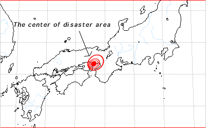
Epicenter of the 1994
Earthquake
The Earthquake and
Tsunami of October 4, 1994 - Most affected by this earthquake and the tsunami
that was generated were the islands of Shikotan, Kunashir and
Iturup, in the South Kurils - and the small islands between Shikotan
and Hokkaido (Yeh et al, 1995). Maximum tsunami runup on Shikotan
Island was reported to be approximately 10 m (about 30 feet)
high. Hokkaido was only affected by the tsunami. Maximum tsunami
runup along the coast of Hokkaido, Japan, was 1.8 meters (at
Nemuro).
REFERENCES
AND FURTHER READING
The following are
selected references for further reading on the kinematics of
tectonic interactions along the Japanese and Kuril Island arcs
and in the Sea of Japan which historically have produced numerous
destructive earthquakes.
Aida, I. (1984), A
source models of the 1983 Nihonkai-earthquake tsunami, Proceeding
of 3rd UJNR(UnitedStates-Japan Cooperative Program in Natural
Resources) Tsunami Workshop, pp. 57-76.
GELABERT, B., SABAT, F., RODRIGUEZ-PEREA, A. , and FORNS, J.,
2001. ON THE ORIGIN OF ARCUATE FOLDED BELTS AND BACK-ARC BASINS,
GSA Annual Meeting, November 5-8, 2001 Session No. 137
Nakamura, K., V. Renard, J. Angelier, J. Azema, J. Bourgois,
C. Deplus, K. Fujioka, Y. Hamano, P. Huchon, H. Kinoshita, P.
Labaume, Y. Ogawa, T. Seno, A. Takeuchi, M. Tanahashi, A. Uchiyama,
and J. L. Vigneresse. Oblique and near collision subduction,
Sagami and Suruga troughs -Preliminary results of French-Japanese
1984 KAIKO cruise, leg 2 Earth Planet. Sci. Lett. 83 229-242
1987.
Kawakatsu, H., and T. Seno, 1983. Triple seismic zone and the
regional variation of seismicity along the northern Honshu arc.
J. Geophys. Res. 88 4215-4230 1983
Ogawa, Y., T. Seno,
H. Akiyoshi, H. Tokuyama, K. Fujioka, and H. Taniguchi, 1989.
Structure and development of the Sagami Trough and off-Boso triple
junction. Tectonophysics 160 135-150, 1989
Nakasa, Y., and T.
Seno. Compensation mechanism of the Yamato Basin, Japan Sea J.
Phys. Earth 42 187-195 1994
NIDP (1999), Study
on tsunami hazards mitigations along the Korean eastern coast(I),
Report of NIDP (National Institute for Disaster Prevention),
192 pp.
Ogawa, Y., T. Seno,
H. Akiyoshi, H. Tokuyama, K. Fujioka, and H. Taniguchi. Structure
and development of the Sagami Trough and off-Boso triple junction
Tectonophysics 160 135-150, 1989
Kawakatsu, H., and
T. Seno. Triple seismic zone and the regional variation of seismicity
along the northern Honshu arc. J. Geophys. Res. 88 4215-4230
1983
Renard, V., Nakamura,
K., J. Angelier, J. Azema, J. Bourgois, C. Deplus, K. Fujioka,
Y. Hamano, P. Huchon, H. Kinoshita, P. Labaume, Y. Ogawa, T.
Seno, A. Takeuchi, M. Tanahashi, A. Uchiyama, and J. L. Vigneresse.
Trench triple junction off central Japan - Preliminary results
of French-Japanese 1984 KAIKO cruise, leg 2 Earth Planet. Sci.
Letters 87 243-256 1987
Pararas-Carayannis G. 1983, The Earthquake and Tsunami of 26
May 1983 in the Sea of Japan
http://drgeorgepc.com/Tsunami1983Japan.html
Pararas-Carayannis
G. 1994, The Earthquake and Tsunami of The Earthquake and Tsunami
of October 4, 1994 in the Kuril Islands
http://drgeorgepc.com/Tsunami1994RussiaKurils.html
Pararas-Carayannis
G. 1999. Assessment of Tsunami Generation from Earthquakes in
the Taiwan and the Southern Ryukyu Islands Region,
http://drgeorgepc.com/Earthquake1999Taiwan.html
Pararas-Carayannis,
G. 2006. THE EARTHQUAKE AND TSUNAMI OF 15 NOVEMBER 2006 IN THE
KURIL ISLANDS
http://drgeorgepc.com/Tsunami2006Kurils.html
Seno, T. 1999. Is
northern Honshu a microplate? Tectonophysics 115 177-196, 1985
Seno, T. Syntheses
of the regional stress fields of the Japanese islands The Island
Arc 8 66-79 1999
Seno, T., and Y. Yamanaka.
1998. Arc stresses determined by slabs: Implications for mechanisms
of back-arc spreading. Geopys. Res. Lett. 25 3227-3230, 1998
Seno, T., and Y. Yamanaka. 1996. Double seismic zones, compressional
deep trench - outer rise events and superplumes in Subduction
Top to Bottom, edited by G. E. Bebout, D. W. Scholl, S. H. Kirby,
and J. P. Platt Geophys. Monogr. 96 347-355, 1996
Seno, T., T. Sakurai,
and S. Stein, 1996. Can the Okhotsk plate be discriminated from
the North American plate? J. Geophys. Res. 101 11305-11315, 1996
Seno, T. Intraplate
sesmicity in Tohoku and Hokkaido and large interplate earthquakes:
A possibility of a large interplate earthquake off the southern
Sanriku coast, northern Japan J. Phys. Earth 27 21-51 1979
Seno, T. 1979. Pattern of intraplate seismicity in southwest
Japan before and after great interplate earthquakes Tectonophysics
57 267-283 1979
Seno, T., Shimazaki, K., Somerville, P., Sudo, K., and T. Eguchi.
Rupture process of the Miyagi-Oki, Japan, earthquake of June
12, 1978 Phys. Earth Planet. Inter. 23 39-61, 1980
Seno, T., and B. Pongsawat,
1981. A triple-planed structure of seismicity and earthquake
mechanisms at the subduction zone off Miyagi Prefecture, northern
Honshu, Japan Earth Planet. Sci. Lett. 55 25-36, 1981
Seno, T., and G. C.
Kroeger. 1983. A reexamination of earthquakes previously thought
to have occurred within the slab between the trench axis and
double seismic zone, northern Honshu J. Phys. Earth 31 195-216,
1983
Seno, T., and T. Takano, 1989. Seismotectonics at the trench-trench-trench
triple junction off central Honshu. Pure Appl. Geophys. 129 27-40,
1989
Seno, T. and D. G.
Gonzalez. 1987. Faulting caused by earthquakes beneath the outer
slope of the Japan Trench. J. Phys. Earth 35 381-407 1987
Tanioka, Y., and K. Satake (1996). Fault parameters of the 1896
Sanriku tsunami earthquake estimated from tsunami numerical modeling,
Geophys. Res. Letters, 23-13,1549-1552.
Watanabe, T., T. Koyaguchi,
and T. Seno. Tectonics stress controls on ascent and emplacement
of magmas J. Volcanol. Geotherm. Res. 91 65-78, 1999
BIBLIOGRAPHY
ON THE SEISMOTECTONICS OF THE KURIL ISLAND/HOKKAIDO REGION
Aver£yanova V. N. (1975).
Depth seismotectonics
of island arcs. Moscow, 1975,
in Russian.
Belyaevsky N. A., Rodnikov A. G. (1972). Crustal structure of the island arcs and Far
Eastern Seas. Article 1. Island Arcs.
International Geology Review, v. 14, No. 2, 1972.
Bikenina S. K., Anosov G. I., Argentov V. V. and Sergeev
K. F. (1987). The
Earth crust structure of the southern part of Okhotsk Sea according
to seismic data. Nauka, Moscow,
1987, 87 pp., in Russian.
Bogdanov N. A. (1988). Deep
basin tectonics of margin seas. Nedra,
Moscow, 1988, 221 pp., in
Russian.
Boldyrev S. A., Gainanov A. G. and Stroev P. A. (1993). Density inhomogeneities of the
lithosphere and dynamics of the North-West Pacific active belt. In: Marine Gravity Investigations (P.A.Stroev,
ed.). National Geophysical Committee, Moscow, 1993,
106-119, in Russian with English abstract.
Burmin V. Yu., Savrina L. A. and Kugaenko Yu. V. (1992). Velocity section of the upper
mantle of the Okhotsk Sea region with using deep foci earthquakes
data. Volcanology and Seismology,
No. 2, 1992, 64-75, in Russian.
Deep seismic
sounding of the Earth crust of Sakhalin-Hokkaido seaside zone.Eds. S. M. Zverev and Y. V. Tulina(1971)
Nauka, Moscow, 1971, 286 pp., in Russian.
Fedotov S. A., Chernyshev S. D., Chernysheva G. V. and Vikulin
A. V. (1980). Determination
of the boundaries of earthquakes sources with M>=7 3/4, peculiarities
of seismic cycle and long-term seismic prediction for the Kurile-Kamchatka
arc. Volcanology and Seismology,
No. 6, 1980, 52-67, In Russian.
Frolova T. I., Perchuk L. L. and Burikova I. A. (1989). Magmatism and transformation
of the Earth crust of the active margins.
Nauka, Moscow, 1989, 261 pp., in Russian.
Geology-geophysical
atlas of the Kuril-Kamchatka island system. Deep structure of
the North-East Japan Arc and its relationship to seismic and
volcanic activity. Eds. K.F.Sergeev
and M.L.Krasny. Institute of Marine Geology and Geophysics,
1987, 40 pp.
Hilde T. W. C., Uyeda S. and Kroenke L. (1977).Evolution of the Western Pacific
and its Margin.
Tectonophysics, v. 38, No. 1/2,
1977, 145-165.
Honza, E., and K. Tamaki, (1985).
The Bonin Arc, in
The Ocean Basins and Margins, edited
by A. E. M. Nairn et al., Vol. 7, pp. 459-502, Plenum Co., New
York, 1985.
Isezaki N., Yosui M. and Uyeda S. (1976). Possible spreading centers in the Japan Sea. In: Geological-geophysical researches of the
transition zone from the Asiatic continent to the Pacific Ocean.
Sov. radio, Moscow, 1976, 72-80.
Jolivet, L., and K. Tamaki,(1992).
Neogene kinematics
in the Japan Sea region and volcanic activity of the NE-Japan
arc, in Proc. ODP, Sci. Results,
edited by Tamaki, K., Suyehiro, K., Allan, J., McWilliams, M.,
et al., Vol. 127/128, Pt.2, pp. 1311-1331, College Station, TX
(Ocean Drilling TAMU), 1992.
Jolivet, L., K. Tamaki, and M. Fournier, (1994). Japan Sea, opening history and
mechanism: a synthesis, J. Geophys.
Res., 99, 22237-22259, 1994.
Khain V. E., Lomize M. G. (1985). Geotectonics with elements of geodynamics. Moscow State University, 1995, 480
pp, in Russian.
Kimura, G., and K. Tamaki, (1985).Tectonic framework of the Kuril
Arc since its initiation, in Formation
of Active Ocean Margins, edited by N. Nasu et al., pp. 641-676,
Terrapub., Tokyo, 1985.
Kimura, G., and K. Tamaki, (1986).
Collision, rotation,
and back-arc spreading: the case of the Okhotsk and Japan Seas, Tectonics, 5, 389-401, 1986.
Kobayashi, K., M. Nakanishi, K. Tamaki,
and Y. Ogawa, (1998). Outer
slope faulting associated with the western Kuril and Japan trenches, Geophys. J. Int., 134, 356-372, 1998.
Krasny M. L. (1990). Geophysical
fields and deep structure of the Okhotsk-Kuril region.
Dalnevost. Otdel. Akad. Nauk USSR,
Vladivostok, 1990, 161 pp.,
in Russian.
Lyapishev A. M., Sychev P. M. and Semenov V. Yu. Structure of electroconductivity
of the upper mantle of Kuril Basin of Okhotsk Sea. Tihookeanskaya Geologia, No. 4, 1987,
45-50, in Russian.
Oscorbin L. S. (1977).Sakhalin seismicity. In: Seismic Zoning of Sakhalin
(S.L.Solov'ev, ed.).
SakhKNII, Vladivostok, 1977, in Russian.
Pisciotto, K., K. Tamaki et al., (1989).
Exploring the Japan
Sea, Geotimes, 1989.
Rodnikov A. G. (1968). About
tectonics of Iturup Island. Vestnik
MGU, Geology, No. 6, 1968,
92-94, in Russian.
Rodnikov A. G. (1979). Island
arcs of the western part of the Pacific Ocean.
Nauka, Moscow, 1979, 152 pp., in Russian.
Rodnikov A. G., Khain V. E. (1971). On the trend in evolution of the Earth's crust
in the north-western part of the Pacific mobile belt. In: Island
Arcs and Marginal Sea (S.Asano and
G.Udintsev, eds.). Tokai University Press, 1971, 65-76,
in Japanese.
Rodnikov A. G., Rodnikova R. D. (1974). The Japan - Sakhalin Island Arc. Nauka, Moscow, 1974, 74 pp., in Russian.
Rodnikov A. G., Rodkin M. V., Ermakov B. V. et al. (1994).
The Okhotsk Sea Geotraverse.
27th
General Assembly IASPEI, Wellington, NZ., 1994, S8.51.
Rogozhin E. A.
(1996). Focal mechanism of the Neftegorsk (Sakhalin) earthquake
of May 27(28), 1995. Geotectonics,
No. 2, 1996, 45-53, in Russian.
Semenov R. M., Pavlenov V. A. and Charahinov V. V. (1996).
Catastrophic earthquake
at the north Sakhalin (short seismogeological characteristic). Dokl. Akad. Nauk SSSR, v. 351, No. 4, 1996,
535-538, in Russian.
Semenova G. I., Zorina Yu. G., Kunin N. Ya. and Rodnikov
A. G. (1986). Upper
mantle zoning of the Pacific with using geophysical investigation
data. In: Structure and Dynamic of
Transition Zones from Continent to Ocean. (V.V.Belousov, M.E.Artem'ev
and A.G.Rodnikov, eds.). Nauka, Moscow, 1986, 57-65,
in Russian.
Sergeev K. F. (1976). Tectonics
of Kuril island system. Nauka,
Moscow, 1976, 239 pp., in Russian.
Snegovskoi S. S. (1974). Reflection
method investigations and tectonics of the southern part of Okhotsk
Sea and adjacent frontier area of the Pacific.
Nauka, Novosibirsk, 1974, 86 pp., in Russian.
Soloviev S. L., Oscorbin L. S. and Ferchev M. D. (1967). Earthquakes at Sakhalin. Nauka, Moscow, 1967, 178 pp., in Russian.
Structure of
the Okhotsk Sea floor. Ed. V. V.
Beloussov, Nauka, Moscow, 1981, 176 pp., in Russian.
Structure of
the floor of the north-western Pacific.
Eds. Yu. M. Pushcharovsky and Yu. P. Neprochnov. Nauka, Moscow,
1984, 231 pp., in Russian.
Structure and
dynamics of the lithosphere and asthenosphere of the Okhotsk
Sea region. Eds. A. G. Rodnikov,
I. K. Tuezov and V. V. Charahinov. National Geophysical Committee,
Nauka, Moscow, 1996, 340 pp., in Russian.
Sychev P. M. (1979). Deep
and surface tectonics processes of the north-western Pacific
mobil belt. Nauka, Moscow, 1979,
208 pp., in Russian.
Tamaki, K., (1985). Two modes of back-arc spreading, Geology, 13, 475-478, 1985.
Tamaki, K., and E. Honza, (1985) Incipient subduction and obduction along the
eastern margin of the Japan Sea,
Tectonophys., 119, 381-406, 1985.
Tamaki, K., (1988). Geological structure of the Japan Sea and its
tectonic implications, Bull. Geol.
Surv. Japan, 39, 269-365, 1988.
Tamaki, K., and E. Honza, (1991).
Global tectonics
and formation of marginal basins: a role of the western Pacific, Episodes, 14, 224-230, 1991.
Tamaki, K., (1995). Opening tectonics of the Japan Sea, in Backarc
Basins: Tectonics and Magmatism,
edited by B. Taylor, pp. 407-420, Plenum Press, New York, 1995.
Tamaki, K., and I. I. Bersenev, (1996). Morphology of the Japan Sea,
in Gelogy and Geophysics of the Japan Sea (Japan-USSR Monograph
Series, Vol 1), edited by N. Isezaki, I. I. Bersenev, K. Tamaki,
B. Ya. Karp, and E. P. Lelikov, pp. 35-39, Terra Scientific Publishing
Company (Terrapub), 1996.
Tamaki, K., and N. Isezaki, (1996). Tectonic synthesis of the Japan Sea based on the collaboration of the Japan-USSR
Monograph Project, in Gelogy and Geophysics of the Japan Sea
(Japan-USSR Monograph Series, Vol 1), edited by N. Isezaki, I.
I. Bersenev, K. Tamaki, B. Ya. Karp, and E. P. Lelikov, pp. 483-487,
Terra Scientific Publishing Company (Terrapub), 1996.
Tarakanov R. Z. (1992). (1972). Structure of the focal zone of the Kuril-Kamchatka
island arc.
In: The Earth Crust of the Island Arc and Far East Seas (N. A.
Beliaevsky, A. G. Gainanov and A. G. Rodnikov, eds.), Nauka,
Moscow, 1972, 215-234, in Russian.
Tectonics of
the north-western Pacific Ocean.
Ed. A. G. Rodnikov. Nauka, Moscow, 1983, 120 pp., in
Russian.
Tuezov I. K. (1975). The
lithosphere of transition zone from Asia to Pacific. Nauka, Novosibirsk, 1975, 232 pp.,
in Russian.
Vasilenko N. F., Bogdanova E. D. (1986). Horizontal movements of the Earth surface in
zone of the central Sakhalin deep fault.
Pacific Geology, No. 3, 1986, 45-49, in Russian.
Vasiliev B. I. (1988). The
main features of the geological structure of North-West part
of Pacific. Vladivostok, 1988,
192 pp., in Russian.
Zlobin T. K. (1989). Lithosphere
sructure in the region of the Iturup Island from seismic data.
Pacific Geology, No. 3, 1989, 33-41, in Russian.
Zlobin T. K., Zlobina L. M. (1991)The Earth crust structure of the Kuril Island
system. Pacific Geology, No. 6,
1991, 24-35, in Russian.
RETURN TO


Links
to other Pages
 NEW BOOK - THE
BIG ONE- The Next Great California Earthquake
NEW BOOK - THE
BIG ONE- The Next Great California Earthquake
 now available from
Amazon, Barnes and Noble and other major bookstores. It can be
also ordered by contacting directly Aston
Forbes Press.
now available from
Amazon, Barnes and Noble and other major bookstores. It can be
also ordered by contacting directly Aston
Forbes Press.

OTHER MISCELLANEOUS NON-TECHNICAL WRITINGS


|