THE
EARTHQUAKE AND TSUNAMI OF 17 JULY 2006 IN SOUTHERN JAVA, INDONESIA
George
Pararas-Carayannis

 The Earthquake The Earthquake
A major earthquake
off the southern coast of the Island of Java in Indonesia generated
a destructive tsunami. Most of the deaths and damage were caused
by the tsunami.
Earthquake
Origin Time, Magnitude, Epicenter and Focal Depth
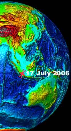
The earthquake with
a moment magnitude of 7.7 occurred on Monday, July 17, 2006 at
08:19:25 (UTC - Coordinated Universal Time) or 3:19 PM local
time in Indonesia. According to the US Geological Survey (NEIC)
the quake's epicenter was at 9.334 S, 107.263 E along the southern
coast of the Island of Java, in Indonesia - about 355 km (220
miles) South of Jakarta, 265 km (165 miles) south of Bandung
(Java), 245 km (155 miles) SSW of Tasikmalaya (Java), 225 km
(140 miles) NE of Christmas Island and about 180 km (110 miles)
off the coastal area of Pangandaran.
Aftershocks
Following the major
earthquake event there three strong aftershocks over the next
three hours, followed by a series of many more in subsequent
hours.
Felt Reports
The earthquake was
strongly felt hundreds of miles away in Jakarta where tall buildings
swayed. The Modified Mercalli intensity was IV at Bandung, Jakarta,
Pangandaran and Tasikmalaya; It was III at Cianjur and II at
Karangkates, Sawahan and Yogyakarta. It was also felt at Bantul,
Banyumas, Ciamas, Cilacap, Garut, Kebumen, Sukabumi and Surabaya.
However, many residents along the coast said that they did not
feel the quake's motions before the tsunami struck. However,
others claimed that they did feel the earthquake but did not
realize that a tsunami had been generated until the heard the
roar of the first wave.

Death Toll
and Damages
The earthquake and
tsunami killed at least 600 people and injured 431 people across
six districts along Central and West Java provinces. More than
230 are still missing and feared dead. The death toll is expected
to rise. Most deaths were caused by the tsunami along coastal
fishing villages and along the beaches at the Pangandaran resort
in West Java's Ciamis district, about 270 kilometers (170 miles)
southeast of
Jakarta. A total of 68,464 people were displaced.
 Recent Earthquakes near Java Recent Earthquakes near Java
Earthquakes occur
very frequently in all the islands of Indonesia, in the inland
seas, and along the Great Sunda Trench. The region near and south
and east- southeast of Java has produced several earthquakes
in recent times.
Satellite photo of
the Island of Java
On 27 May 2006, a shallow 6.3 magnitude earthquake near the city
of Yogyakarta in central Java killed more than 6,000 people and
displaced more than 200,000. A major earthquake (magnitude 7.8)
on 2 June 1994 generated a tsunami that killed more than 200
people. An even greater earthquake (magnitude 8.3) on 20 August
1977, about 1200 km east-southeast of the 17 July 2006 event,
generated a destructive tsunami that also killed about 200 people.
 Tectonic Setting Tectonic Setting
The Indonesian region
is one of the most seismically active zones on earth. It is an
island-arc structure of about 17,000 islands spread out along
a belt of intense volcanic and seismic activity. Such tectonic
features characterize the region as a deep oceanic trench on
the Indian Ocean side, a geanticline belt and volcanic inner
arc, and several marginal basins. Also, the region has about
400 volcanoes, of which about 100 are active. The best known
of the volcanoes is Krakatau in the Sunda Strait, between Java
and Sumatra. The 1883 explosion and collapse of the volcano generated
an enormous tsunami that killed close to 37,00 people.
Subduction of the India plate beneath the Burma plate caused
the great earthquake and the devastating tsunami of 26 December
2004 along the western coast of the island of Sumatra. Another
great tsunamigenic earthquake occurred on 28 March 2005 near
Nias Island off the coast of Sumatra.
Subduction of great tectonic plates continues further south and
east/southeast along the great Sunda Trench. The entire region,
but particularly Java, is tectonically unstable. The offshore
region of southern Java has high seismicity and has produced
many destructive earthquakes - some of which have generated destructive
tsunamis. The offshore seismic activity along the southern coast
of Java results from oblique subduction, as the Australia plate
slides beneath the Sunda plate at a about 60 mm/yr in a north-northeastward
direction.
Oblique subduction of tectonic plates at high rates along Eastern
Indonesia has created a very complex active tectonic zone. As
indicated, the rate of subduction in the West Java Trench where
the 17 July 2006 earthquake occurred is about 60 mm/year. Further
east along the East Java Trench the rate of subduction is about
50 mm/yr. Near New Guinea the subduction rate increases to as
much as 107 mm/yr. Thus, major and great earthquakes occur frequently
in this region.
The Tsunami
of 17 July 2006 in Southern Java
The major earthquake
of 17 July 2006 generated a destructive local tsunami that impacted
about 129 miles of the southern coast of the Island of Java.
Tsunami waves of up to 5 meters in height swept through fishing
villages and resorts on Indonesia's Java Island destroying houses,
restaurants, hotels, boats, and spreading devastation half a
km inland. The death toll rose to more than 600, with hundreds
more missing. The death toll is expected to climb. More than
54,000 people were displaced.
Tsunami
Warning issued but not disseminated
Both the Pacific Tsunami
Warning Center in Honolulu and the Japan Meteorological Agency
sent warning bulletins to authorities in Indonesia 45 minutes
before the tsunami struck Java. However the warnings were not
announced and the people in the threatened area were not notified.
The authorities did not announce the warnings because they did
not want to cause unnecessary alarm.
To this day - in spite of the 2004 devastating tsunami that killed
more than 250,000 people in the countries of the Indian Ocean,
including 170,000 in Indonesia - there is still no operating
local system of sirens, alarms, or other type of communication
on the island of Java that can provide effectively warnings to
people along vulnerable coastlines. In the year and a half following
the 2004 tsunami disaster, all efforts to install an early warning
system have concentrated on the Island of Sumatra and deep ocean
sensors are in place off the coast. However, even this system
is not yet fully operational and no tsunami warning system has
been set up yet for the southern coast of Java - although one
is planned for completion by 2007.
Tsunami
Travel Time and Extent of Inundation
According to eyewitnesses
the first wave reached the nearest shore of southern Java within
half hour after the earthquake. Subsequent larger waves reached
about half a km (300 yards) inland.
 Tsunami Effects Tsunami Effects
Waves of up to four
to five meters struck the coastline along the southern coast
of the island of Java. The waves were particularly destructive
along the Pangandaran coast.
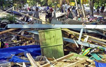
Pangandaran: Hardest hit by the tsunami were
the beaches at Pangandaran - a resort community near Ciamis town,
270 km (170 miles) southeast of Jakarta. Waves up to 5 meters
high crashed and swept cars, motorbikes and boats into hotels
and storefronts, flattened homes and restaurants, and flooded
rice fields up to 500 meters (550 yards) from the sea along a
stretch of the densely populated coastline. Most of the reported
deaths occurred in this area.
Batu Keras Beach: According to eyewitnesses at
Batu Keras beach, 30 kilometers west of Pangandaran, the water
withdrew for about 5 minutes and people on the beach, instead
of running to higher ground, went out to look at stranded fish
- just before the first roaring wave hit the shoreline at about
4.30 p.m., local time. A total of six waves were reported - the
second being the biggest and as high as four to five meters.
 Ciamis:
in the town of Ciamis,
270km southeast of Jakarta in West Java, the larger hotels around
the beach remained standing, but many of the smaller buildings
and dozens of homes were destroyed. Many people lost their lives. Ciamis:
in the town of Ciamis,
270km southeast of Jakarta in West Java, the larger hotels around
the beach remained standing, but many of the smaller buildings
and dozens of homes were destroyed. Many people lost their lives.
Tsunami Destruction
at Pangandaran 
Port of Cilacap: Extensive damage occurred at
the central Java port of Cilacap and many people were killed.
 Satellite
photo showing extent of the tsunami inundattion along part of Pangandaran Beach
taken on July 19, 2006 by the commercial satellite ICONOS.
Satellite
photo showing extent of the tsunami inundattion along part of Pangandaran Beach
taken on July 19, 2006 by the commercial satellite ICONOS.
Cristmas Island:
The tsunami
registered a maximumum height of 60 centimeters/
Tsunami
Generating Mechanism
The 17 July 2006 tsunami
was generated by thrust faulting along the boundary between the
Australia plate and the Sunda plate.

 Past Tsunamis in Java,
near Java and East of Java Past Tsunamis in Java,
near Java and East of Java
Several destructive
tsunamis have occurred in this region in the past.
East Java
- June 2, 1994
A large, shallow thrust,
major earthquake (with moment magnitude of 7.8) off the southeastern
coast of Java - near the east end of the Java Trench in the Indian
Ocean - generated a devastating tsunami (which was much larger
than expected for the size of the earthquake). Twenty to thirty
minutes after the main shock, tsunami waves arrived at the nearest
coasts. The most severe tsunami damage occurred along the southern
coast of East Java where waves ranging in height from 1-14m.
Along the southwestern coast of the Island of Bali the waves
ranged from 1-5 meters. In total, 223 persons lost their lives,
approximately 400 were injured, and over 1000 houses were destroyed.
Flores Island
- 12 December 1992
An earthquake of magnitude
7.8, with epicenter about 35 km NW off the north coast of the
eastern part of Flores Island near Maumere - its largest city
- generated a local tsunami which killed 1690 people and destroyed
approximately 18,000 houses. The tsunami's first wave arrived
on the shores of Flores within two minutes after the initial
shock, and reached the north shore within five minutes. Huge
waves with runup of up to 26.2 m completely overrun and destroyed
Riang-Kroko, a small village at Cape of Watupajung at the extreme
NE end of Flores Island, killing 137 people.
Elsewhere on Flores Island the tsunami runup ranged form 2 to
5.2 m, peaking at Kolisia village, an area which also experienced
maximum subsidence from quake ground movement. Tsunami waves
of up to 2.9 meters completely inundated the small, densely populated
village of Wuhring (Wuhring island), located on a low spit about
3 km NW of Maumere. The waves destroyed most of the houses and
killed 87 of the 1400 people living there. Waves with runup of
up to 4.6 m also overrun the low lying village of Nebe on Flores
island, destroying nearly all the homes and killing two people.
On the island of Babi, located about 40 km NE of Maumere, waves
with maximum runup of 5.6 m killed 263 of the island's 1,093
inhabitants.
Lesser Sunda
Islands - Sumba, Sumbawa - 19 August 1977
On August 19, 1977
a great earthquake (moment magnitude 8.3)occurred in the Java
Trench, westward of Sumba Island. The quake was very widely felt
and caused people in Perth, Australia, more than 2000 Km southward,
to flee from office buildings. A major tsunami was generated.
The tsunami arrived on the Indonesian coast about an hour or
two after high water, and commenced with a recession that frequently
left an additional 100-200 meters of beach exposed. Three large
waves followed at intervals of perhaps 5 minutes or less, the
first being, the highest and most destructive, with a maximum
run-up height of 15 meters. The waves penetrated about 500 meters
inland in some valleys and killed almost 200 people and left
3900 homeless.
An unusual feature was that between the time of the quake
and the tsunami arrival residents in Sumbawa and Lombok communities
heard up to 3 explosive sounds, over a period estimated from
a few seconds to a minute or more, and these were described variously
as sounding like bombs, aircraft breaking the sound barrier,
or thunder. The sound in each case came more or less from the
direction of the epicenter. Almost every community reported the
water turning black, and some claimed also it increased in temperature
and bad a bad odor.
Along the Australian coast, as in Indonesia ,three major waves
came in with the first being the largest. A wave height of 2
meters was reported at Dampier, 2 to 4 meters at Port Sampson,
and 6 meters at Cape Leveque. The tide was falling and, at most
places, it was near low and this reduced the tsunami impact.
There was apparently no loss of life in Australia, though it
is reported that at least one person was swept into the sea by
the waves.The disturbance continued for a number of hours.
REFERENCES
- Additional Sources of Background Information
Hamilton, W., 1979,
Tectonics of the
Indonesian region:
U.S. Geological Survey Prof. Paper 1078.
Pararas-Carayannis, G. International Tsunami Information Center
A Progress Report
For 1974-1976. International
Coordination Group for the Tsunami Warning System in the Pacific,
Vina Del Mar, Chile, 1977.
Pararas-Carayannis, George, International Tsunami Information
Center,Tsunami Report 77-12 , Tsunami
Reports for 1977.
Pararas-Carayannis,
G., Indonesian Earthquake
and Tsunami of August 19, 1977,
Intern. Tsunami Information Center Report, Abstracted article
in Tsunami Newsletter, Vol. X, No. 3, September, 1977.
Pararas-Carayannis,
G. 1989. Five-Year
Plan for The Development of A Regional Warning System in the
Southwest Pacific.
A Report prepared to the United Nations Development Program (UNDP),
New York, May 1989, 21 p. _
Pararas-Carayannis,
G. 2004. TSUNAMI
INFORMATIONAL KIT
Prepared for UNESCO-INTERGOVERNMENTAL OCEANOGRAPHIC COMMISSION.
Sept. 2004
Pararas-Carayannis,
G., The Great Earthquake
and Tsunami of 28 March 2005 in Sumatra, Indonesia
http://drgeorgepc.com/Tsunami2005ndonesia.html
Pararas-Carayannis,
G. The Great Earthquake
and Tsunami of 26 December 2004 in Southeast Asia and the Indian
Ocean
http://drgeorgepc.com/Tsunami2004Indonesia.html
Pararas-Carayannis,
G. NEAR AND FAR-FIELD
EFFECTS OF TSUNAMIS GENERATED BY THE PAROXYSMAL ERUPTIONS, EXPLOSIONS,
CALDERA COLLAPSES AND MASSIVE SLOPE FAILURES OF THE KRAKATAU
VOLCANO IN INDONESIA ON AUGUST 26-27, 1883, Presentation for the International Seminar/Workshop
on Tsunami "In Memoriam 120 Years Of Krakatau Eruption _
Tsunami And Lesson Learned From Large Tsunami" August 26th
_ 29th 2003, Jakarta and Anyer, Indonesia. Also published in
the Journal of Tsunami Hazards, Volume 21, Number 4. 2003
http://www.STHJOURNAL.ORG
http://drgeorgepc.com/Tsunami1883Krakatau.html
Pararas-Carayannis,
G. The Great Tsunami
of August 26, 1883 from the Explosion of the Krakatau Volcano
("Krakatoa") in Indonesia
http://drgeorgepc.com/Tsunami1883Krakatoa.html
Return to

  Links to other
Pages
Links to other
Pages

 Now available
from Amazon, Barnes and Noble and other major bookstores. A signed
by the author copy can be also ordered by contacting directly
by email Aston
Forbes Press.
Now available
from Amazon, Barnes and Noble and other major bookstores. A signed
by the author copy can be also ordered by contacting directly
by email Aston
Forbes Press.
 Other
Miscellaneous Non-technical Writings
Other
Miscellaneous Non-technical Writings
(©) Copyright
1963-2007 George Pararas-Carayannis / all rights reserved / Information
on this site is for viewing and personal information only - protected
by copyright. Any unauthorized use or reproduction of material
from this site without written permission is prohibited.
|